


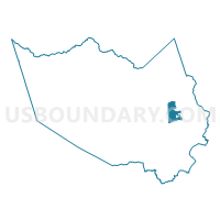
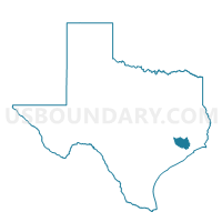
Voting District 0220, Harris County, Texas
About
Outline

Summary
| Unique Area Identifier | 673850 |
| Name | Voting District 0220 |
| County | Harris County |
| State | Texas |
| Area (square miles) | 14.92 |
| Land Area (square miles) | 12.60 |
| Water Area (square miles) | 2.31 |
| % of Land Area | 84.48 |
| % of Water Area | 15.52 |
| Latitude of the Internal Point | 29.82814510 |
| Longtitude of the Internal Point | -95.09563740 |
Maps

Graphs
Select a template below for downloading or customizing gragh for Voting District 0220, Harris County, Texas


Neighbors
Neighoring Voting District (by Name) Neighboring Voting District on the Map
- Voting District 0063, Harris County, TX
- Voting District 0141, Harris County, TX
- Voting District 0251, Harris County, TX
- Voting District 0381, Harris County, TX
- Voting District 0382, Harris County, TX
- Voting District 0460, Harris County, TX
- Voting District 0502, Harris County, TX
- Voting District 0740, Harris County, TX
- Voting District 0834, Harris County, TX
Top 10 Neighboring County Subdivision (by Population) Neighboring County Subdivision on the Map
- Houston CCD, Harris County, TX (3,075,388)
- Baytown CCD, Harris County, TX (72,734)
- Northeast Harris CCD, Harris County, TX (59,937)
Top 10 Neighboring Place (by Population) Neighboring Place on the Map
- Houston city, TX (2,099,451)
- Channelview CDP, TX (38,289)
- Highlands CDP, TX (7,522)
- Barrett CDP, TX (3,199)
- Sheldon CDP, TX (1,990)
Top 10 Neighboring Unified School District (by Population) Neighboring Unified School District on the Map
- Goose Creek Consolidated Independent School District, TX (99,072)
- Deer Park Independent School District, TX (49,499)
- Channelview Independent School District, TX (36,550)
- Sheldon Independent School District, TX (30,569)
- Crosby Independent School District, TX (24,689)
Top 10 Neighboring State Legislative District Lower Chamber (by Population) Neighboring State Legislative District Lower Chamber on the Map
- State House District 127, TX (187,102)
- State House District 142, TX (154,794)
- State House District 128, TX (148,817)
Top 10 Neighboring State Legislative District Upper Chamber (by Population) Neighboring State Legislative District Upper Chamber on the Map
Top 10 Neighboring 111th Congressional District (by Population) Neighboring 111th Congressional District on the Map
Top 10 Neighboring Census Tract (by Population) Neighboring Census Tract on the Map
- Census Tract 2523.02, Harris County, TX (11,443)
- Census Tract 2522, Harris County, TX (7,944)
- Census Tract 2529, Harris County, TX (7,768)
- Census Tract 2526, Harris County, TX (7,552)
- Census Tract 2524, Harris County, TX (6,976)
- Census Tract 2528, Harris County, TX (5,882)
- Census Tract 2525, Harris County, TX (4,325)
- Census Tract 2527, Harris County, TX (4,163)
- Census Tract 2533, Harris County, TX (3,428)
- Census Tract 2521, Harris County, TX (1,720)
Top 10 Neighboring 5-Digit ZIP Code Tabulation Area (by Population) Neighboring 5-Digit ZIP Code Tabulation Area on the Map
- 77520, TX (36,489)
- 77530, TX (31,086)
- 77044, TX (30,949)
- 77049, TX (28,521)
- 77532, TX (26,236)
- 77562, TX (10,459)